Although I love the city the summer always makes me itch to get out into the country. So I called up my friend Karel with whom I had helped organize a conference many years ago and asked him if he would mind getting together in his neck of the woods near Burlington for a country driving tour of the Niagara Escarpment. Since we had not seen each other for a couple of years it was a great opportunity to catch up and enjoy a beautiful drive at the same time.

Lookout point at Mount Nemo Conservation area
So we met this morning on a parking lot just off Guelph Line in the north end of Burlington. I parked my car and off we drove in Karel’s convertible. We drove north into the green countryside and up a slope to get to our first destination: a nature area called the Mount Nemo Conservation Area. We parked the car and walked about 15 minutes eastwards through a forest until we reached a steep cliff and a lookout point that offered a beautiful 180 degree view over the rolling farm country that was sprawling far below us.

Farmland sprawling below Mount Nemo Conservation Area
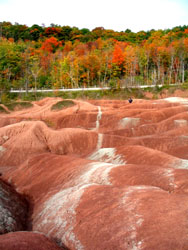
The Niagara Escarpment is a geological formation that extends from western New York State through Ontario to Michigan, Wisconsin and Illinois. It originated as a result of unequal erosion where a top layer of harder and more resistant dolomitic limestone overlays more easily eroded shale. The gradual erosion of the shale leaves behind cliffs of resistant cap rock. The limestone itself stems from an ancient tropical sea and contains some of the most astounding fossils of the Ordovician-Silurian geological era.

A view of the limestone formations on the Niagara Escarpment
In Ontario, the Niagara Escarpment features the Bruce Trail: Canada’s oldest and longest footpath that extends over 800 km (with side trails) from Niagara Falls in the South to Tobermory in the north. The entire area has been designated a UNESCO World Biosphere Reserve due to its unique fauna and flora. The Bruce Trail itself is marked by white blazes (white markings about 8 cm high and 3 cm wide) and is maintained by the Bruce Trail Association while side trails are marked by blue blazes.

The ruggedness of the Niagara Escarpment
One of the Niagara Escarpments distinguishing features are the many lookout points on the rocky outcroppings over an otherwise rather flat area. In addition, the Niagara Escarpment has dozens of waterfalls where streams and rivers tumble over the limestone cliffs. The most famous of these waterfalls is of course Niagara Falls which is also reachable on a side trail from the Bruce Trail.

Rock faces dropping vertically down
The Niagara Escarpment’s unique natural environment includes many bird species (some of them endangered) such as the Bald Eagle, the Red-Shouldered Hawk, the Black Tern and the Hooded Warbler. Rare reptiles and amphibians also live in the area, for example the Eastern Massassauga Rattlesnake and the North Dusky Salamander. 37 species of orchids have been found in the northern parts of the Escarpment, including the Calypso Orchid, the Ram’s-head Lady Slipper and Alaska Rein Orchid. Considering that about 7 million people live within close proximity the biological diversity in this unique area is astounding.

The Sixteen Mile Creek in Lowville
We started walking on a trail right at the edge of a cliff and Karel informed me that the Niagara Escarpment is extremely popular with rock climbers. I wanted to take a good snapshot of the cliffs and crevices, but my fear of heights and the shear vertical drop prevented me from exploring the very edge of the cliff. The many caves are also popular with spelunkers. We walked about 20 minutes northwards and had a beautiful view towards Rattlesnake Point, another rocky outcrop along the Niagara Escarpment. Then we took a side trail back through the forest to the parking lot and continued our drive.

The Lowville Bistro
About ten minutes further north we stopped in the village of Lowville to have a look at Lowville Park. The Sixteen Mile Creek slowly meanders through the park and nature trails branch off from the parking lot area. Right next to the park is the Lowville Bistro, a recently renovated restaurant that offers upscale casual dining, a licensed outdoor patio, an ice cream parlour and take-out. The town itself dates back to the early 1800s and was developed after the Mississauga Land Purchase. The descendants of some of these early settlers still live in the village today. 36 historic buildings and a Pioneer Cemetery still bear witness to this once thriving rural community.

Entrance to the Iroquoian Village at Crawford Lake Conservation Area